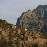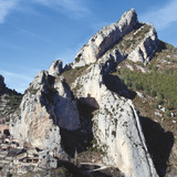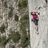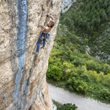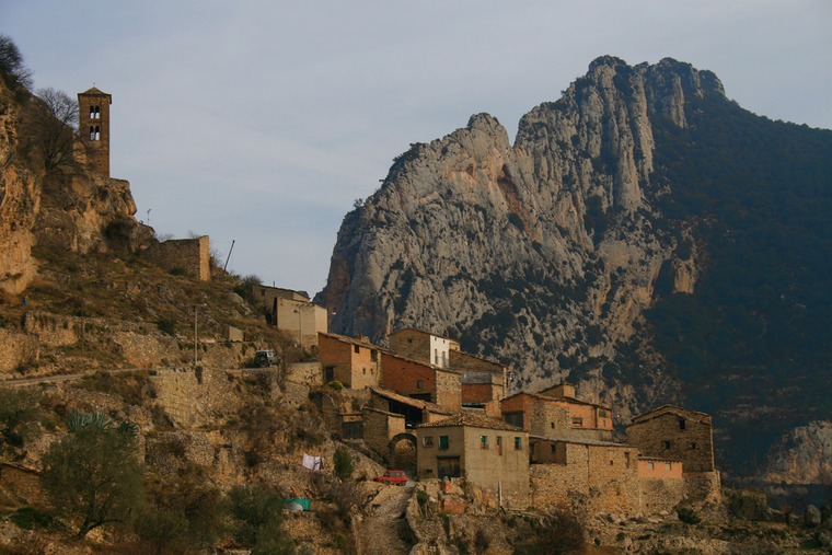
For sheer beauty the tiny village of Abella de la Conca and its surrounding cliffs are almost without equal in the province of Lleida. The rock formations are stunning — spectacular crests and fins jutting into the sky — while the village itself must be one of the most splendidly situated in the whole of Catalunya. This part of Lleida seems blessed with a particularly favourable micro-climate resulting in very little rainfall and above average sunshine, though thanks to the various orientations of the sectors climbing is possible throughout the year. The predominant style of climbing in Abella is technical and fingery, on rock that varies in angle from steep slabs to gently overhanging walls and in this genre hundreds of excellent routes are available throughout the grades (although it should be noted that some of the harder routes on the ‘gently’ overhanging walls are far from gentle!). However, there are also plenty of cracks and diedres, and those looking for really steep rock will undoubtedly find the awe-inspiring arches of El Forat dels Lladres to be a worthy challenge.
🧗♂️Sectors🧗♂️
Les Ajagudes
🧗♂️: This small slab of smooth, compact rock is situated to the west of the village. It was originally equipped as a sort of ‘beginner’s’ sector offering low-grade, low-stress slab routes, but in fact, the climbs were horrendously undergraded and the sector attained a certain reputation. The grading has now been adjusted! Orientation: South. Note: a seasonal bird-ban exists for this sector — no climbing between March 1st and August 31st.
🚶♂️: From P1 walk back down the road for some 200m to the surfaced track on the right. Walk along this for approximately 450m then follow a trail, first rightwards through a small plantation of almond trees then steeply up to the base of the sector (12 minutes).
Sector Voltor
🧗♂️: A great sector offering a number of excellent, technical routes. Orientation: South. Note: a seasonal bird-ban exists for this sector — no climbing between February 1st and May 31st.
🚶♂️: From P1 walk back down the road for some 200m to the surfaced track on the right. Walk along this for approximately 230m to a cairn on the right marking the start of a narrow trail leading up and back rightwards to the base of the sector (10 minutes).
Mur Blau
🧗♂️: A beautiful sector featuring technical and fingery routes up to 50m in length! Orientation: West. Note: a seasonal bird-ban exists for this sector — no climbing between March 1st and August 31st.
🚶♂️: From P1 walk back down the road for some 200m to the surfaced track on the right. Walk along this for approximately 230m to a cairn on the right marking the start of a narrow trail leading up and back rightwards towards the base of sector Voltor. Approximately 30m along the narrow trail fork left by a cairn to reach a small outcrop of yellow rock after 20m. Continue up a path (cairn) passing a large oak tree (30m) and then an unfinished climb with two bolts. The path leads to the base of a gully where the lower two routes of the sector are situated (12 minutes from P1). The routes on the higher part of the sector require a further 5 minutes’ scrambling up the gully aided by some fixed ropes.
Altiplano
🧗♂️: This impressive sector lies to the right of sector Voltor and offers yet more technical and fingery climbing. Orientation: South.
🚶♂️: From P1 walk up the road towards the village to reach the surfaced turning area. On the left-hand side of this a narrow trail starts, passing close to a prominent cherry tree after a few metres. Follow the path (vague in places) predominantly leftwards for approximately 200m, then continue scrambling more directly uphill, passing cairns, to the base of the sector (12 minutes).
Sector Església
🧗♂️: A really nice cliff and probably the best sector in Abella for climbers operating in the 4th, 5th and 6th grades. Orientation: South.
🚶♂️: From P1 walk up the road for 400m to reach the splendidly situated square in the higher part of the village, where there is a ‘Font’ (water fountain). Directly opposite the Font a narrow alleyway leads up and leftwards, passing the church of Sant Esteve, a fine example of Romanic architecture. About 30m further on pass a small building (water deposit) on its left-hand side and then continue along a well-marked path leading to the right-hand side of the sector (8 minutes from P1). Routes on the left-hand side of the sector require a few minutes more. Routes 1-6 are located on a separate buttress situated above and to the left of the main sector.
Pirámide
🧗♂️: This fine, slabby cliff lies on the slope above sector Església and gives delightful 5th grade climbing. Orientation: Southeast.
🚶♂️: The first part of the approach is as for Sector Església — from P1 walk up the road for 400m to reach the splendidly situated square in the higher part of the village, where there is a ‘Font’ (water fountain). Directly opposite the Font a narrow alleyway leads up and leftwards, passing the church of Sant Esteve, a fine example of Romanic architecture. About 30m further on pass a small building (water deposit) on its left-hand side and then continue along a well-marked path leading to the right-hand side of sector Església (8 minutes from P1). Just right of route number 48 on sector Església it is possible to scramble up slabby rock to reach the slope above. Continue up a steep, vague trail to reach the foot of the sector Pirámide (15 minutes from P1). Note: this scrambling approach may feel fine going up, but caution is needed if descending in darkness or damp conditions.
Sector Ferrata
🧗♂️: A very nice sector offering perfect rock and superb face climbing. The projects on the higher section of the wall are crying out for the attention of 9th grade activists! Orientation: East.
🚶♂️: The first part of the approach is as for Sectors Església and Pirámide — from P1 walk up the road for 400m to reach the splendidly situated square in the higher part of the village, where there is a ‘Font’ (water fountain). Directly opposite the Font a narrow alleyway leads up and leftwards, passing the church of Sant Esteve, a fine example of Romanic architecture. About 30m further on pass a small building (water deposit) on its left-hand side and then continue along a well-marked path leading to the right-hand side of sector Església (8 minutes from P1). Just right of route number 48 on sector Església it is possible to scramble up slabby rock to reach the slope above. Continue up a steep, vague trail to reach the foot of the sector Pirámide. From here continue up and rightwards to Sector Ferrata, which is situated just to the right of the start of the metal rung access for sector El Forat dels Lladres (20 minutes from P1).
El Forat dels Lladres
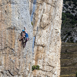
🧗♂️: An outstanding natural phenomenon — three huge arches (two of them free-standing) tucked away in a fold of the hillside and almost hidden from below. The best of the climbing lies on the highest arch and features wildly overhanging 8th grade tufa-action, but even if you don’t plan to climb at all it really is worth going just for a look. Orientation: in general, East, but the architecture of the crag means certain areas will be shaded whatever the time of day.
🚶♂️: The first part of the approach is as for Sectors Església, Pirámide and Ferrata — from P1 walk up the road for 400m to reach the splendidly situated square in the higher part of the village, where there is a ‘Font’ (water fountain). Directly opposite the Font a narrow alleyway leads up and leftwards, passing the church of Sant Esteve, a fine example of Romanic architecture. About 30m further on pass a small building (water deposit) on its left-hand side and then continue along a well-marked path leading to the right-hand side of sector Església (8 minutes from P1). Just right of route number 48 on sector Església it is possible to scramble up slabby rock to reach the slope above. Continue up a steep, vague trail to reach the foot of the sector Pirámide. From here continue up and rightwards to Sector Ferrata From the base of the left-hand side of Sector Ferrata ascend the spur above aided by in-situ iron rungs. This is very exposed and there are no fixed ropes to clip into on the spur itself. At the top of the steep section there is a two-bolt belay. From here continue, first rightwards (fixed ropes for assistance) and then back left on a vague path to reach the first of the three magnificent rock-arches (30 minutes from P1). Note 1: this approach is unsuitable for non-climbers and dogs! Note 2: when descending the spur, climbers usually choose to rappel from the two-bolt belay; a single, doubled 70m rope is just long enough to get down to easier ground, but an 80m is better.
La Costera
🧗♂️: La Costera (‘The Rib’) is the name given to the impressive fins of rock overlooking the village on its Northeastern side. For climbing purposes, it is divided into a number of sub-sectors, with each having its own distinct character and orientation. In total there are close to 100 routes here.
🚶♂️: From P1 walk up the road for 400m to reach the splendidly situated square in the higher part of the village, where there is a ‘Font’ (water fountain). From the village square continue following the narrow road downhill. The first routes are situated on a large buttress on the left, just beyond the last dwelling — La Costera Pobla (Orientation: East). La Costera Nord (Orientation: East), La Costera Alta/Martí (Orientation: South) and La Costera Pista (Orientation: South) are situated in a gully just above the road and reached by scrambling up a very steep path. La Costera Pista - Nord and La Contra Costera (Orientation: North) are situated on the northern side of the major fin. From P1 count on approximately 8 minutes to reach the closest sub-sector (La Costera Pobla ) and as much as 20 – 25 minutes to reach the furthest (La Contra Costera). Note: reaching the upper part of La Costera Alta/Martí requires the use of a fixed rope to overcome a short, tricky section — unsuitable for non-climbers.
El Congost
🧗♂️: This superb sector, located in a small valley some 3km west of the village, offers extremely technical and fingery face-climbing on immaculate rock. It will delight those who revel in this style of climbing but will not suit power fanatics! Orientation: Southeast.
🚶♂️: When driving towards the village of Abella de La Conca, approximately 400m before reaching it (and 200m before P1) a surfaced track cuts sharply back left (there are several mailboxes at the junction). Turn onto this and drive along it in a westerly direction, heading away from the village. Approximately 1.5km from the junction with the main road, the track (now unsurfaced) splits: the left fork is the private access for a farm. Take the right-hand, narrower track (there is a small, orange BTT Mountain Bike trail marker where it starts) passing behind the farm buildings, then re-join the main track shortly afterwards. Park 300m further on (P2), immediately before the track swings left in a sweeping bend, approximately 3km from the junction with the main road. On foot, follow a vague trail for approximately 150m up the hillside in a northerly direction before merging with a more prominent path coming in from the right. Pass through the debris of a rock-slide and continue up the valley to the base of the sector (20 minutes from P2).
El Canyon
🧗♂️: This sector is situated in the spectacular gorge directly below the village. The main wall is incredibly impressive, proof of which being that only one of the six lines on this section of the cliff has actually been climbed (at 8c!) while the other five remain projects. Orientation: Southwest. Note: routes 1-3 require belaying from a hanging stance reached by an exposed traverse leftwards — unsuitable for non-climbers.
🚶♂️: Driving in from Isona, approximately 650m before reaching P1, turn right onto an unsurfaced track and follow this for roughly 1.1km to a parking area (P3). On foot, continue along the diminishing track heading towards the narrowest part of the gorge. Cross the stream using natural stepping-stones then follow a path (cairns) up through the bushes to reach the base of the sector (10 minutes).
Font de les Gotes, Lo Morral & Panorama
🧗♂️: These three sectors are situated on the opposite side of the gorge and offer superb views of the village. The climbing is mostly vertical and in the 6th and 7th grades. Orientation: Southwest for Font de Les Gotes and Panorama, West for Lo Morral.
🚶♂️: Driving from Isona, approximately 2.5km from the junction with the L-511 (and also 2.5km before the village) there is a prominent leftwards hairpin bend with an unsurfaced track cutting off to the right. Follow the track uphill for approximately 1km to a junction. Take the left fork (the right one is private) and continue for a further 800m to another junction, which is also passed to the left. Continue driving for approximately 1.3km to reach a parking area (P4) below a small buttress — this is Font de les Gotes. Approximately 200m further along the track a large cliff towers above the road — Lo Morral, with Sector Panorama just to its right. Parking spaces are limited but the best option is to continue driving along the track for 30m to a place where it is possible to turn around and also park (P5).