Description

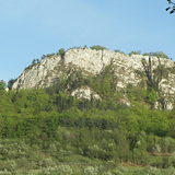
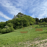
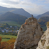
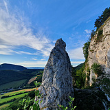
This sector consists of a group of limestone cliffs towering above the tiny village of Kostolec. The three rock towers and the views were probably best described in 1987 by Jozef Boško, in a mountaineering guide from Kostolecká úžina and Bosmany: “Bosmany is above all beautiful. It is beautiful for its landscape, but also for its climbing. Standing in the middle of fields and meadows, the cliffs seem to float in a sea of light and silence. During spring and autumn evenings, when the sun takes its time to set in a great arc behind the wide landscape and when the sporadic sounds from the fields and the village accentuate the silence in man. ... The whitish walls of the Kostolecká and Manin Straits reflect the colour of the western sky, and the bluish ribbon of the Javorníky mountains winds in the distance.”

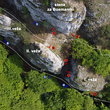
It should be noted that the name Bosmany is the only original name of the climbing crag in the entire Manín and Kostolecká Straits that originates from local residents. Other crags have been named by climbers. It is said that the name bosman means cake. And sure enough, the towers remind of three cookies rising above the village, a temptation for the climbers to bite into them. And so it happened in 1946. Today, the area offers more than 30 routes. When viewed from the village, the towers are marked from right to left as Bosman I, II and III, occasionally also referred to as the right, the middle and the left Bosman.

History

The very first routes were climbed here in 1946 in traditional style. After a prolonged "climbing break" the towers were rediscovered in late 70s and about dozen of routes were climbed in traditional style.
Then the towers were rediscovered again by climbers around the year 2000. All newer routes from these years were bolted from the top.
In 2022 many routes were rebolted.

Bosmany

Climbing has been limited!

Attention!!! Climbing is permitted from 15.6. to 31.12.

Approach by car: From Považská Bystrica continue to the village Považská Teplá and then to Manínska Strait. Cross the strait and then from the village of Záskalie, continue through the Kostolecká Strait and after the strait turn right to the village steep uphill. Parking for 2—3 cars is available in front of the cemetery on the side of the road (it is necessary to park completely on the side to leave the passage free) or for more cars in the village, near the fire station.

From the car park in front of the cemetery: a paved gravel road leads slightly uphill to the east. After some 400m, there is a meadow on the left hand side — see photo. Continue through the meadow and into the forest. A higher path leads to the Wall behind the Towers and to the Eastern wall of the second tower. The lower trail leads under the Western Walls. All of the Towers can be contoured behind the third tower. 

From the car park at the fire station: walk around the bus stop and from the tarmac road right above it, find a path between the gardens. The path leads directly up to the towers. From the meadow, continue as described above.