Description

*** CSX boulders are water dependent, see below.

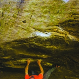
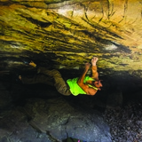
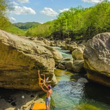
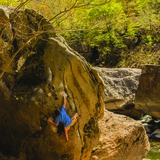
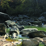
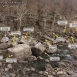
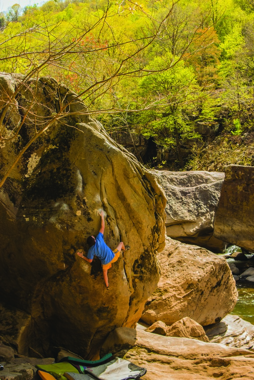
CSX is a true New River Dries experience. Large, water smoothed boulders sit along and in the river. Although often under-featured, the lines that do emerge on the Dries tend to be pure and proud. The area is a delight to explore even without the climbing, a new section of river bank hidden behind each boulder cluster. Comfort with navigating riverside talus is helpful, as while all of the boulders sit in a narrow strip between the cliff line and water, there may be only one narrow, cryptic path. Climbing over and between boulders is often required. The rough terrain has its benefits -- it is rare to see other people here, even fellow climbers. This area caters most to the V8-V10 climber with "Judah" and the "David and Goliath" variations being unique-for-the-New, non-morphologic roof climbing on small crimps/edges.

🚶‍♂️ Approach summary - Very rugged approach. Work gloves are recommended for the knotted rope on the steep approach gully. People have been injured from loose rock in this gully. Hiking time 15 to 45 minutes.
💎 Notable problems - "Celestial Dawn" V3, "Kokopelli" V5, "Badass" V5 (best in early fall, be ready to wade), "The Raven" V8, "The Tipple" V8, "Lipstick" V9, "Judah" V10, "David and Goliath" V10/11
💧 Dry time - Hours to 1 day. No additional wait time needed once rock is visibly dry.
🍂❄️🍃 Seasonal Beta - Best fall to spring, it is warm on the river in the summer.
🌊 Water Level Beta - Highly water level dependent and is best at minimum flow (about 4.35 ft), see below.
🚗 Drive from downtown Fayetteville - 15 minutes
🚗 Drive from Summersville - 40 minutes
🚽 Bathrooms - None. There may be toilets installed soon at the riverside parking area just upstream.
📶 Cell phone service - 2/5, spotty.
🐶 Dogs - Dogs are okay. Be careful with your dog along the road. Dogs must be agile who can navigate a steep hillside and riverside talus.

*** Be sure to check water levels before making the approach. This area is highly water dependent and it is advised to go during minimum flow especially for first timers. It is difficult to get farther downstream than the Compression Project Boulder if the water is not at minimum flow. The water is usually minimum flow for most of July through at least the end of October. Minimum flow is currently about 4.35 ft (it used to be under 4ft, but the minimum flow has increased in the past few years). You can check the level at: https://waterdata.usgs.gov/usa/nwis/uv?380649081083301

History

As the New River flows north through its most rugged stretch, it passes through the famous cliffs that make up the world class route climbing destination, the New River Gorge. Just past the popular Bubba City climbing area the majority of the good cliff peters out and the river pools up behind Hawk's Nest Dam. At this point, a large portion of the water flow is tunneled through Gauley Mountain and doesn't rejoin the river until just upstream of the town of Gauley Bridge, about 6 miles downstream. Because of the lessened flow in the stretch below the dam, much of the bedrock and, more importantly for us, the boulders that used to sit at the bottom of the river are exposed. It is known as 'The Dries'.

The Hawk's Nest Tunnel was built in 18 months starting in spring of 1930. The project attracted approximately 5000 young men hoping to find work during the Great Depression, but this is not a happy story. With little to no protective equipment, inadequate ventilation, lack of dust control, substantial racial inequality as at least 2/3 of the workers were black, and the rock being made up of almost 100% silica led to a lot of silica dust in workers' lungs. This led to 'silicosis', which is a lung disease where the lungs are filled silica. Silicosis usually develops over decades of working with stone and breathing in silica dust, but in this case, most workers only worked 6 months in the tunnel before they quit, got too sick, or died of silicosis. At least 764 - mostly black - people died, making the Hawk's Nest Tunnel Disaster one of the largest industrial disasters and the greatest death toll from silicosis in American history. Today, you can learn more and visit the graves of some of these workers near the Whippoorwill Boulders (also routes and swimming hole) parking area.

Sources:
https://www.nps.gov/neri/planyourvisit/the-hawks-nest-tunnel-disaster-summersville-wv.htm
https://www.npr.org/2019/01/20/685821214/before-black-lung-the-hawks-nest-tunnel-disaster-killed-hundreds
https://www.nhs.uk/conditions/silicosis/#:~:text=Silicosis%20is%20a%20long%2Dterm,that%20can%20be%20easily%20inhaled.

CSX Boulders

The area is access sensitive!

🔴This area is water level dependent. The minimum level is 4.35ft. You can find the current water level at this site:
https://waterdata.usgs.gov/monitoring-location/380649081083301/#parameterCode=00065&period=P7D

🚗 Driving:
From Fayetteville, drive north on WV-16, heading straight through the intersection with US-19. Drive about 8.5 miles to a stop sign at the intersection with US-60. Make a careful U-turn at the odd intersection and head back the way you came. After crossing over the first bridge, park in the next pullout on your right. This is labeled "Parking 7".

Hiking:
This is a challenging hike, and after a steep descent requires scrambling over riverside talus. From the parking, walk south (upstream, towards Hawks Nest Dam, further up the road in the direction that your car is pointing). Follow a 2-3ft high hump of ground on the outside of the guard rail. The hump disappears into a steep ravine, then starts up again. When it flattens out, hop over the guard rail (there is usually a cairn here) and follow the faint trail down the pretty steep hill. The trail heads downhill briefly, then traverses the hill left to a fixed rope (inexplicably this sometimes gets stolen. If there is no rope, don't go down the hill). Use the rope for the even steeper hill all the way to the river. Work gloves are helpful. The fist cluster of boulders is upstream from the approach trail (if you're facing the river, to the left), but most boulders are downstream. The trail is long, steep, and poorly maintained with a handline. Once you reach river level, the walking is adventurous with rock hopping, scrambling, and routefinding. Total hiking time: 15-45 minutes.