Description

🔴 CSX Left boulders are accessed from a different parking area than the main CSX Boulders. See approach directions.
🔴 CSX Left boulders are water dependent, see below.

🔴 ACCESS WARNING: Walking along railroad tracks is trespassing, illegal and dangerous. Do NOT walk on railroad tracks; trespassing and any illegal activity associated with climbers will jeopardize access to boulders. If you chose to use the rail corridor to access boulders, you must walk off the tracks and off the gravel that is private CSX property. The only tolerated exception is CAREFULLY crossing directly from one side of the tracks to the other, going from NPS land to NPS land. If you are near tracks, keep your eyes and ears open for trains and keep a large distance from the gravel. Trains are dangerous; coal and rocks often fall from or are thrown by trains. Trains can't stop. Don't make the conductor think they have any chance of running you or your dog over. Be respectful and polite to any railroad worker you see. This is VERY important to future access to all climbing areas near train tracks.

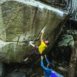
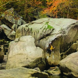
CSX is a true New River Dries experience. Large, water smoothed boulders sit along and in the river. Although often under-featured, the lines that do emerge on the Dries tend to be pure and proud. The area is a delight to explore even without the climbing, a new section of river bank hidden behind each boulder cluster. Comfort with navigating riverside talus is helpful, as while all of the boulders sit in a narrow strip between the train tracks and water, there may be only one narrow, cryptic path. Climbing over and between boulders is often required. The rough terrain has its benefits -- it is rare to see other people here, even fellow climbers.

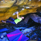
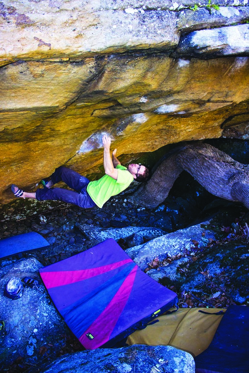
CSX Left is visited even less than the main CSX boulders but not for a lack of classics. The moderates here are incredible and deserve more attention than they receive. Proud, stand-out lines include "Delta River Bleau" V6 and then risky "Mega Scoop" V5, the latter which graced the bouldering guidebook cover (the landing or Mega Scoop now never gets out of the water -- this has been climbed with no pads; a rope to rehearse the moves is recommended).

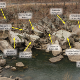
The approach for most boulders involves a long walk on tracks followed by a short but steep and loose scramble down the hill. "The Lorax" V10, an area highlight, can be accessed from directly above this problem and is not water dependent, but it is difficult to get to the remaining boulders from here. Many problems collect mud from the river and will need brushing. You used to be able to rock hop across the river from CSX Right, but due to a raise in water level (and a rock moving), you no longer can. That said, this is a magical place and the boulders are phenomenal.

🚶‍♂️ Approach summary - Very rugged approach. A long walk on railroad tracks is followed by a short but loose and steep scramble down the hill. Hiking time 30 to 45 minutes.
💎 Notable problems - "Ascension Aria" V1, "Wishbone" V3, "Poseidon" V3, "Mega Scoop" V5 (the landing is always wet, see problem description), "Delta River Bleau" V6, "Mandible' V6, "Hermes" V6, "Mercury" V6, "Jupiter" V6, "The Lorax" V10
💧 Dry time - Hours to 1 day. No additional wait time needed once rock is visibly dry.
🍂❄️🍃 Seasonal Beta - Best fall to spring, it is warm on the river in the summer.
🌊 Water Level Beta - Highly water level dependent and is best at minimum flow (about 4.35 ft), see below.
🚗 Drive from downtown Fayetteville - 11 minutes
🚗 Drive from Summersville - 36 minutes
🚽 Bathrooms - None. There may eventually be toilets installed at the riverside parking area just downstream of Hawks Nest Dam and Cotton bottom parking.
📶 Cell phone service - 2/5, spotty.
🐶 Dogs - Dogs are okay. Be careful with your dog along the road and railroad tracks. Dogs cannot easily get to the Lorax boulder.

***Be sure to check water levels before making the approach. This area is less water dependent than CSX Right Boulders (which are on river right, across the river from these boulders). "The Lorax" should not go under water except during record-breaking flooding. The boulders from including Colliding Cells Boulder and UPstream (again, excepting The Lorax Boulder which can be accessed separately) are unreachable at any significant flow above minimum. Some of the boulders down stream are water level dependent but the area is still navigable within a couple feet of minimum. The water is usually minimum flow for most of July through at least the end of October. Minimum flow is currently about 4.35 ft (it used to be under 4ft, but the minimum flow has increased in the past few years). You can check the level at: https://waterdata.usgs.gov/usa/nwis/uv?380649081083301

History

As the New River flows north through its most rugged stretch, it passes through the famous cliffs that make up the world class route climbing destination, the New River Gorge. Just past the popular Bubba City climbing area the majority of the good cliff peters out and the river pools up behind Hawk's Nest Dam. At this point, a large portion of the water flow is tunneled through Gauley Mountain and doesn't rejoin the river until just upstream of the town of Gauley Bridge, about 6 miles downstream. Because of the lessened flow in the stretch below the dam, much of the bedrock and, more importantly for us, the boulders that used to sit at the bottom of the river are exposed. It is known as 'The Dries'.

The Hawk's Nest Tunnel was built in 18 months starting in spring of 1930. The project attracted approximately 5000 young men hoping to find work during the Great Depression, but this is not a happy story. With little to no protective equipment, inadequate ventilation, lack of dust control, substantial racial inequality as at least 2/3 of the workers were black, and the rock being made up of almost 100% silica led to a lot of silica dust in workers' lungs. This led to 'silicosis', which is a lung disease where the lungs are filled silica. Silicosis usually develops over decades of working with stone and breathing in silica dust, but in this case, most workers only worked 6 months in the tunnel before they quit, got too sick, or died of silicosis. At least 764 - mostly black - people died, making the Hawk's Nest Tunnel Disaster one of the largest industrial disasters and the greatest death toll from silicosis in American history. Today, you can learn more and visit the graves of some of these workers near the Whippoorwill Boulders (also routes and swimming hole) parking area.

Sources:
https://www.nps.gov/neri/planyourvisit/the-hawks-nest-tunnel-disaster-summersville-wv.htm
https://www.npr.org/2019/01/20/685821214/before-black-lung-the-hawks-nest-tunnel-disaster-killed-hundreds
https://www.nhs.uk/conditions/silicosis/#:~:text=Silicosis%20is%20a%20long%2Dterm,that%20can%20be%20easily%20inhaled.

CSX Left Boulders

The area is access sensitive!

🔴This area is water level dependent. The minimum level is 4.35ft. You can find the current water level at this site:
https://waterdata.usgs.gov/monitoring-location/380649081083301/#parameterCode=00065&period=P7D

🔴 ACCESS WARNING: Walking along railroad tracks is trespassing, illegal and dangerous. Do NOT walk on railroad tracks; trespassing and any illegal activity associated with climbers will jeopardize access to boulders. If you chose to use the rail corridor to access boulders, you must walk off the tracks and off the gravel that is private CSX property. The only tolerated exception is CAREFULLY crossing directly from one side of the tracks to the other, going from NPS land to NPS land. If you are near tracks, keep your eyes and ears open for trains and keep a large distance from the gravel. Trains are dangerous; coal and rocks often fall from or are thrown by trains. Trains can't stop. Don't make the conductor think they have any chance of running you or your dog over. Be respectful and polite to any railroad worker you see. This is VERY important to future access to all climbing areas near train tracks.

🚗 Driving:
From Fayetteville, drive north on WV-16 heading straight through the intersection with US-19. Drive about 7 miles, and park on the just-wide-enough shoulder on your right immediately before crossing over the bridge across the New River. Be careful not to miss the parking, as the shoulder slowly widens around a curve in the road, becoming widest just as the bridge comes into view.
🔴 THE parking is around a blind curve, take care when exiting your vehicle. There is also limited parking for only a few cars and shares a pullout with the Casey Jones boulders. If there is no more room, please choose another climbing area for the day.

Hiking:
From the parking, cross the road and head down the paved driveway to the tracks. This road/building are associated with the tracks, so be discreet. Walk downstream (that's to your left. Don't pass under the bridge) parallel the tracks. The Lorax trail is marked by a cairn; this trail is primarily to access the Lorax as it sits halfway up the cliff side. If you are going to ANY other boulder it is easier to continue downstream until you can find the steep, loose but open scramble to the river. This will overgrow every summer, there is no well established trail to the river. Good luck. The trail is mainly flat, uneven gravel. The trail down the hill to river level is non-existant, so you'll have to routefind a way down the steep hill. Once you reach river level, the walking is adventurous with rock hopping, scrambling, and routefinding. Total hiking time: 30-45 minutes.