Deutsch:
Dürnbachtal
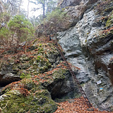
Das Dürnbachtal ist ein kleines Seitental des Piestingtals und somit die schattige Rückseite der Hohen Wand. Vom unteren Dürnbachtal kann man über die Große Klause auf die Hohe Wand aufsteigen und zum Beispiel über das Waldeggerhaus (1005 m) über die Kleine Klause ins obere Dürnbachtal absteigen. Diese beiden Felsschluchten ziehen nicht nur Kletterer an den Wochenenden an, sondern auch viele Wanderer. Dadurch sind die Parkplätze im Dürnbachtal sehr begrenzt.
Hohe Stube
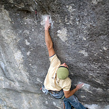
Diese in der Großen Klause gelegene, westseitig ausgerichtete Wand, die sich oberhalb des Gamswandl befindet, bietet senkrechte bis überhängende Routen mit scharfen Löchern und Leisten im rauen Kalk. An der rechten Seite der Wand imponiert die braune Höhle. Alle Routen sind perfekt mit Klebehaken abgesichert, jedoch sind manche Stellen doch zwingend zu klettern. Im Winter ist es hier meist ungemütlich, da die Sonne fast nicht zur Wand kommt. Die meisten Routen siedeln sich im Grad 6c bis 7a an und sind bis auf wenige Ausnahmen 18 bis 20 Meter hoch.
Gamswandl
Auch in der Großen Klause gelegen, befindet sich das Gamswandl direkt am Wanderweg. Hier wird manch Kletterer, der sich an den technisch anspruchsvollen Plattenrouten versucht, von den Wanderern wohl bestaunt. Die Routen (bis 30 Meter) hier sind löchrig, plattig, glatt und sehr anspruchsvoll. Der "lange Weg..." und seine Nachbarrouten bleiben bis zum späten Nachmittag im Schatten, sind aber teilweise lange feucht. Die Routen um Reiwalata bekommen früher Sonne, jedoch nur in den oberen Bereichen der Wand. Die Top-Tour hier: „Keine Händ, keine Keks.“
Schatzinsel
Diese beliebte, westseitig ausgerichtete Wand bietet Routen bis 18 Meter Höhe im Schwierigkeitsbereich 7a aufwärts. Der Kalk hier erscheint blau, und die kraftvolle Kletterei an Löchern und vor allem Auflegern ist für diese Region selten. Außerdem befindet sich der wohl größte Sinter der Hohen hier. Ein Muss ist natürlich die „Mei Thai“, die an besagtem Sinter beginnt. Wenn es geregnet hat, bleibt die Wand jedoch recht lange feucht, obwohl ihre Nachbarwände schon längst trocken sind.
Bachwand
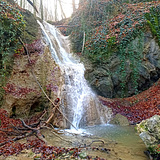
Dieser kleine, aber feine Block liegt unfern des Dürnbacher Wasserfalls und ist fast nordseitig ausgerichtet. Durch die Nähe zum Wasser und den dichten Efeu bleibt auch dieser Block nach Regenfällen eher länger feucht. Das Absprunggelände ist sehr gut, und ein kleines Crashpad reicht vollkommen aus.
English:
Dürnbachtal
The Dürnbachtal is a small side valley of the Piestingtal and thus the shady backside of the Hohe Wand. From the lower Dürnbachtal, you can ascend to the Hohe Wand via the Große Klause and, for example, descend into the upper Dürnbachtal via the Waldeggerhaus (1005 m) and the Kleine Klause. These two gorges attract not only climbers on weekends but also many hikers. As a result, parking spaces in the Dürnbachtal are very limited.
Hohe Stube
This west-facing wall located in the Große Klause, which lies above the Gamswandl, offers vertical to overhanging routes with sharp pockets and edges in rough limestone. On the right side of the wall, the brown cave impresses. All routes are perfectly secured with glue-in bolts; however, some sections are still mandatory to climb. In winter, it is usually uncomfortable here as the sun hardly reaches the wall. Most routes are graded between 6c and 7a and are, with few exceptions, 18 to 20 meters high.
Gamswandl
Also located in the Große Klause, the Gamswandl is directly along the hiking path. Here, many climbers attempting the technically challenging slab routes are likely to be admired by hikers. The routes (up to 30 meters) here are slabby, smooth, and very demanding climb on pockets. The "Der lange Weg..." and its neighboring routes remain in the shade until late afternoon but can stay wet for a long time. The routes around Reiwalata receive sun earlier, but only in the upper sections of the wall. The top route here is: “Keine Händ, keine Keks”.
Schatzinsel
This popular west-facing wall offers routes up to 18 meters high in the difficulty range from 7a onwards. The limestone here appears blue, and the powerful climbing on pockets and especially on slopers is rare for this region. Additionally, the largest sinter of the Hohe Wand is found here. A must-try is the "Mei Thai," which starts at this particular sinter. If it has rained, the wall tends to stay wet for a long time, even though its neighboring walls may have dried out.
Bachwand
This small but fine block lies near the Dürnbacher Waterfall and is almost north-facing. Due to its proximity to water and dense ivy, this block also tends to stay wet for a longer time after rainfall. The landing area is very good, and a small crash pad is more than sufficient.