🔴 THIS AREA IS HIGHLY WATER LEVEL DEPENDENT, PLEASE SEE INFORMATION BELOW
Nuttallburg is the largest area with the easiest access for boulders on the banks of the New River. A long, beautiful drive down Keeneys Creek meanders past the bottom of Short Creek before ending at the Nuttallburg town ruins. The rock here is arguably the best in the entire region, bullet hard and often water polished. This guide has been split into different sectors within the whole of Nuttallburg, due to the widely varying directions and the long stretch of river encompassed by this area. Most importantly many of the boulders are water level dependent, best visited in late summer and early fall when the New is routinely at its lowest.
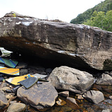
The Ripple Effect Boulder is special. It sits in the river at the top of the Double Z rapid, one of the few Class V rapids on the stretch of river referred to as the Lower New. The boulder is a large pancake with a steep roof on the side facing the bank, easily visible on satellite imagery. The boulder hosts a great range of difficulties with mostly roof climbing over a landing of river polished stones with water trickling around them. In between attempts or while supporting fellow climbers, it is a spectacular location to enjoy the beauty of the river and watch boaters navigate the rapid adjacent the boulder. The other couple of boulders in this cluster also offer great climbing. Not far upstream and downstream are more clusters to explore.
🚶♂️ Approach summary - Moderately rugged. 5 to 7 minutes.
💎 Notable problems - "Strainer" V6, "Ripple Effect" V7, "Wet Exit" V8, "Laminar Flow" V9
💧 Dry time - Hours. When the landing is not under water this area dries extremely quickly. No additional wait time is needed once the rock is visibly dry.
🍂❄️🍃 Seasonal Beta - Best in the late summer and early fall when the New River is at its lowest.
🌊 Water Level Beta - The Ripple Effect Boulder is highly water level dependent. The other boulders in this area are not. For the Ripple Effect Boulder, the water should be BELOW 0.5ft at Fayette Station and BELOW 3.8ft at Thurmond. Note that the Fayette Station gauge is not updated continuously but the Thurmond gauge is updated hourly. The two gauges can be found at:
Fayette Station --> https://www.americanwhitewater.org/content/Gauge2/detail/id/43472/
Thurmond --> https://waterdata.usgs.gov/monitoring-location/03185400/
🚗 Drive from downtown Fayetteville - 33 minutes
🚗 Drive from Summersville - 46 minutes
🚽 Bathrooms - Pit toilets at the parking area.
📶 Cell phone service - 2/5, spotty. There is spotty service in the parking lot and on the bank just downstream of the RIpple Effect Boulder.
🐶 Dogs - Must be leashed at all times. This is National Park land.