
The area is access sensitive
⛔️🅿️ Don't park your car underneath the sector "Tüchersfelder Wand". The property owner is quite unhappy about cars parking on his property. The sector is about to get closed otherwise. Park along the ... Read more
We like Tüchersfeld


Activities on this crag
Nearby crags


The area is access sensitive!
⛔️🅿️
Don't park your car underneath the sector "Tüchersfelder Wand". The property owner is quite unhappy about cars parking on his property. The sector is about to get closed otherwise.
Park along the main road.
🚗
The crag's sectors are located around the village "Tüchersfeld" in the Püttlach-valley between "Pottenstein" and "Behringersmühle". Approaching from West follow signs towards "Behringersmühle" and ahead to "Pottenstein". Approaching from East follow signs towards "Pottenstein" and ahead to "Behringersmühle". Parking is along the main road in "Tüchersfeld".
🚶♂️
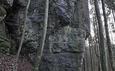
Tüchersfelder Wand:
Leave the village towards "Pottenstein" (east) via the main road. Just a few meters behind the village there's a forest road to your left. Here's a path leading left to the already visible wall.
Christinenwand:
Cross the river and go to the chapel. There are several bridges, the chapel is located at the central bridge and visible from the main road. Go up the steps behind the chapel and keep left along the hillside for 50 meters. The sector is next to the trail.
Schonunger Wand:
Park at the western end of "Tüchersfeld" left handed facing west and get on the hiking trail towards "Behringersmühle" (label with red cross). Follow that trail for about 450 meters until you spot the sector to your left. A small path is leading to the wall.
Wallfahrt:
Park at the western end of "Tüchersfeld" left handed facing west and get on the hiking trail towards "Behringersmühle" (label with red cross). Follow that trail for about 200 meters. After the trail bends left go ahead for about 60 meters until there are some small conifers in the otherwise predominantly deciduous forest. Take off the trail to your left and go up the hill. There are several rocks and boulders facing ahead, pass them to the left. Go ahead until you've reached the top of the hill. go ahead keeping slightly left. In high season you might spot a foot path branching off the hiking trail.