Description

🧗
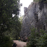
The style of climbing is quite old school here. Predominantly vertical routes on pockets and a lot of classic lines like dihedrals and cracks might delight especially beginners and advanced climbers.
The deeper you keep going into the valley the harder the routes get. At "Wüstenstein" you get hard endurance classics from the 80s and some steep boulder routes at "Wüstenstein Nebenmassiv" or "Dachstein"
"Treunitzer Wand" is ideal for beginners with it's pitted slabs.

🌼🌞🍂
A few sectors get sun at afternoon ("Wüstenstein", "Gelbe Wand") but mainly all routes are quite shady so that the best season is summer and autumn.

💧
The exposed sectors "Treunitzer Pfeiler", "Gelbe Wand" and "Vorderer Paradiestalwächter" dry fast but all other sectors drain after winter or long rain periods. Especially at "Wüstenstein" there are whole waterfalls in between dry sections.. depends on what route you want to climb it can be worth a try. You should know about the local conditions then.
Best temporary rain protected sector is "Wüstenstein".

👶
All sectors are very suitable for kids without doubt. Only exception is "Paradieswand & Bamberger Pfeiler"

🍽🍻🛌
Next Camping is "Camping Waldmühle" in "Freienfels". Best Beer you get at "Brauerei Hübner" in Steinfeld, where you might get the best and cheapest fried potatoes around.
Further chopping facilities are located in "Hollfeld", down south the street.

💎 Goodies

super soft:
- Lichtmessweg
- Schluchtriss

soft:
- Na Bravo
- Zeiselweg
- Verschneidung (Gelbe Wand)
- Nordwand (Vorderer Paradietalwächter)

medium:
- Flug in die Nacht
- Tschernobyl
- Felsteufelweg

hard:
- Nosegrind
- Sahara
- Oase
- Schwarze Wand
- Fata Morgana
- Nikotin Corner
extreme:
- 17 + 4

Wiesent- Paradiestal

Climbing has been limited!

⛔️🧑‍🌾
The bolts at the back sector of "Treunitzer Pfeiler" ("Linker Einstieg" - "Promenadenweg") are chopped off. Obviously the landowner doesn't want the sector to be climbed.

🚗
The most sectors are located in the Valley of "Paradiestal" which is a secondary valley of "Wiesenttal".
Best approach is via the motorway A70 from north. Approaching from south go all the Valley "Wiesenttal" up to "Hollfeld" and ahead the valley towards "Treunitz".
Parking is in a bend between "Treunitz" and "Steinfeld" where the street crosses the river.

🚶‍♂️
Torstein, Treunitzer Pfeiler & Treunitzer Wand:
Take the hiking trail south down the river stream. "Treunitzer Wand" is to your right immediately. Go ahead the hiking trail and you'll pass Treunitzer Pfeiler after 4 minutes and "Torstein" after 5 minutes.

All other sectors are located in the "Paradiestal" which you can enter as well from north. Access to "Wüstenstein" is quicker from north (check out the map) but for the sake of completeness access from south is mentioned here.
For all further sectors follow the street up north for 200 meters where a hiking trail is leading into the valley to your right. All further sectors are located in the valley-bottom next to that trail. Take the hiking trail, then further access information from the beginning of that trail: ->

Vorderer Paradiestalwächter:
this small sector is just next to the hiking trail after 300 meters.

Nasenlöcherturm:
After 520 meters on the right side. A small path is leading to the tower.

Dachstein:
after 850 meters right to the trail.

Gelbe Wand:
after 1.2 km to your right.

Paradieswand & Bambergerpfeiler:
after 1.35 km take the path up the hill to your right. follow that one for 80 meters to "Paradieswand". Go left along the hill side for 80 meters to "Bamberger Pfeiler"

Kulmbacher Wand:
after 1.75 km to your right across the lawn.

Zigeunerstube:
after 2.7 km to your right, just behind the crossroads.

Wüstenstein:
take the path from "Zigeunerstube" to your right following along the edge of the forest. after 100 meters take the foot path leading up the hill to the already visible crag.
Alternative approach from the hiking parking from north, that's just 1.4 km to "Wüstenstein".

Wüstenstein Nebenmassiv:
From where the path leading up the hill to "Wüstenstein". take the forest road to your left leading diagonal up the hill. Take that path for about 80 meters and leave it to the left. The sector is already visible from there.